If you picture mornings on a porch with long marsh views or quick boat rides to the harbor, Mount Pleasant may be your perfect fit. Waterfront life here is special, but the details matter: tides, dock eligibility, flood maps, HOAs, and everyday logistics. In this guide, you’ll learn how different Mount Pleasant waterfronts live, what to verify before you buy, and how to match a property to your lifestyle. Let’s dive in.
What “waterfront” means in Mount Pleasant
Mount Pleasant stretches along the Cooper and Wando Rivers and the edge of Charleston Harbor. You’ll find several distinct settings: open harbor frontage near Old Village, deepwater on the Wando, active tidal creeks like Shem Creek, quiet marshfront, and planned neighborhoods with community docks. Each setting comes with different water depth, wave exposure, public access, and permitting considerations. You’ll want to confirm these early.
Deepwater on the Wando and harbor
Deepwater homes often have private, longer docks, direct access to the Intracoastal and harbor, and room for larger boats. You get quick runs to open water and a classic boating lifestyle. In exchange, expect higher lot values, more permitting and dock upkeep, and greater storm surge exposure. For a helpful overview of deepwater tradeoffs, review this Charleston waterfront neighborhoods primer.
Tidal creek living
Creekfront homes shine for kayaking, shrimping, and a close-to-town feel. Water depth changes with the tide, which affects boat size and launch timing. Shem Creek is both a beloved restaurant district and an active boating spot with a public boardwalk and day dock. The Town periodically upgrades facilities, like the Shem Creek day dock replacement project, which keeps the area lively and accessible.
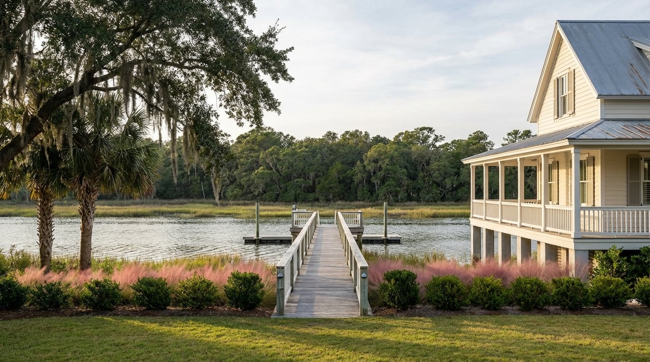
Marshfront views
Marshfront properties offer wide, serene views and abundant wildlife. Most are not deepwater. Dock approvals can be limited by creek width and state rules, and marsh ownership can involve public-trust considerations. Learn how tidelands are regulated and why mean high-water lines matter in this overview of South Carolina public-trust tidelands.
Canal and community docks
Some planned neighborhoods feature canals, shared docks, and community ramps. You get water access with less individual maintenance. You also agree to HOA rules for dock use, storage, and scheduling. Ask about waitlists and maintenance reserves if a community dock is a must-have.
Architecture and neighborhood character
You’ll see a mix of historic and coastal-elevated homes along Mount Pleasant’s waterfronts:
- Old Village harbor cottages and Charleston single-house forms emphasize porches, raised foundations, and preserved streetscapes. Renovations follow local design review in the Mount Pleasant Historic District.
- Modern Lowcountry coastal homes are typically elevated on pilings with wide porches and resilient materials suited to coastal wind and water. See the basics of Lowcountry architecture for common features.
- Master-planned communities such as I’On, Dunes West, Park West, Carolina Park, and Rivertowne offer parks, trails, pools, and in some cases community docks or ramps. These neighborhoods blend water access with amenities and a suburban feel.
Daily life: boats, parks, dining, and commutes
Boating and public access
You can enjoy the water even without a private dock. Mount Pleasant maintains public assets like the Shem Creek boardwalk and parks, Remley’s Point public boat landing, the David Simmons Jr. community dock, and Memorial Waterfront Park with a long pier. These amenities support a waterfront lifestyle and can influence property desirability. See how town facilities shape local recreation in the hazard vulnerability assessment.
If a private dock is vital, verify eligibility. South Carolina sets standards for lot frontage, dock size, spacing, and creek-width limits. Get clear on what the property already has and what you can add. Review state dock standards in S.C. coastal regulations.
Parks and dining
Shem Creek’s restaurants and boardwalk are a favorite for dinner by the water and sunset strolls. Under the Ravenel Bridge, Memorial Waterfront Park offers green space and a signature pier for fishing and views. Local investment in facilities, like the new day dock at Shem Creek, keeps these areas active and accessible.
Commute reality
The Arthur Ravenel Jr. Bridge ties Mount Pleasant directly to the Charleston peninsula, and Coleman Boulevard is a major town artery. Traffic can vary with weather and tides. Test your commute at the hours you plan to drive so you know what to expect.
Dock eligibility, permits, and ownership basics
Before you fall in love with a view, confirm what you can build and use. South Carolina’s coastal rules govern docks, piers, and structures in tidelands. Standards cover minimum lot frontage, dock length and size, spacing from property lines, and joint-use or community dock options. Start with the permitting framework in state coastal regulations and request any existing permits and as-built drawings from the seller.
Ownership at the marsh edge works differently than typical upland lots. The State generally holds regulatory control below the mean high-water line under public-trust principles. That can affect exclusive rights, lease needs, and project approvals. Learn more in this primer on South Carolina tidelands and public trust.
Flood zones, insurance, and risk
Mount Pleasant participates in FEMA’s NFIP and the Community Rating System. The Town adopted revised flood maps and an updated local Flood Damage Prevention Ordinance in 2021. Start with the Town’s flood protection page to identify your panel, find elevation certificate guidance, and understand local standards.
If you use a federally backed mortgage and the home sits in a Special Flood Hazard Area, federal law generally requires flood insurance. Your lender will confirm whether the mandate applies. See an overview of the rule in this Congressional Research Service summary.
FEMA’s Risk Rating 2.0 changed how premiums are calculated. Elevation certificates are not always required to purchase coverage, but they can still help with rating and appeals. Ask a coastal-savvy insurance agent to quote both NFIP and private options.
For long-term planning, use NOAA’s maps to understand possible sea level scenarios over the next 10 to 30 years. The NOAA Sea Level Rise Viewer is a helpful starting point.
Costs and maintenance to expect
Waterfront ownership comes with unique ongoing costs. Budget for dock and boatlift inspections, repairs, and eventual replacement. Coastal homes often need more exterior care due to salt, wind, and moisture. Shoreline stabilization, bulkheads, and erosion control may require periodic work.
Public examples hint at the lifecycle of marine structures. The Town’s plan to replace the Shem Creek public day dock shows how floating docks and hardware age in a saltwater environment. Build a reserve plan for your property or confirm that your HOA has one.
HOA rules and amenity checks
If you are buying in a planned community, read the CC&Rs and budgets in detail. Confirm how docks, ramps, and common areas are funded, scheduled for repair, and reserved for owners. Past local litigation, such as the I’On matter, shows why it is smart to verify promised amenities and conveyances. For context, see the discussion of the case on Let’s Talk Dirt SC. Have a real estate attorney review the documents.
Showing-day checklist
Bring this quick list to every waterfront showing:
- Ask for a recent elevation certificate and the property’s current FEMA map panel. Start with the Town’s flood resources.
- Confirm whether a private dock exists and request copies of permits, approvals, as-built drawings, and repair records. Review relevant state dock standards.
- Check whether the upland boundary includes the mean high-water line or if the marsh is state jurisdiction. Read up on tidelands and public trust basics.
- Obtain property-specific flood insurance quotes and confirm with your lender whether mandatory coverage applies in an SFHA. Here is the CRS overview of the federal mandate.
- If there is an HOA, request CC&Rs, budgets, reserve studies, recent minutes, and any special assessments, plus rules for docks and ramps. Review the I’On case commentary as a reminder to verify promises.
- Book a coastal survey and a marine contractor inspection for docks, pilings, and seawalls. Ask for a written repair and replacement estimate.
- Confirm utilities, sewer connections, and any planned infrastructure projects that could affect access or value.
How Mount Pleasant compares
- Mount Pleasant: A wide range of waterfront options, from Old Village’s historic charm to deepwater estates and amenity neighborhoods, plus direct access to downtown via the Ravenel Bridge. Explore the Mount Pleasant Historic District for a sense of the harbor’s heritage.
- Isle of Palms and Sullivan’s Island: Barrier-island beach living with a more ocean-focused lifestyle and seasonal traffic patterns to consider.
- Daniel Island: A master-planned island community with riverfront parks and a compact, planned feel.
- Charleston peninsula: Historic urban living with strong walkability and different flood and insurance profiles.
Your best choice comes down to priorities: boat size and water depth, beach access, school zones, commutes, and neighborhood character. Use the same due diligence checklist for every property you consider.
Ready for local guidance?
Waterfront decisions are about lifestyle as much as logistics. If you want a calm, expert path from first tour to closing, reach out to Kimberly Lease for buyer representation and a tailored Mount Pleasant waterfront plan. From flood and dock permitting insights to vetted coastal vendors, you will get concierge-level support that helps you buy with confidence. If you are also weighing a sale, ask about our premium marketing and Request Your Free Home Valuation.
FAQs
What does “deepwater” mean in Mount Pleasant?
- Deepwater typically refers to consistent, navigable depth that supports larger boats and shorter runs to open water. Always confirm actual depth at low tide and review eligibility for private docks under South Carolina coastal regulations.
How do flood zones affect design and insurance for waterfront homes?
- Flood zones set minimum elevation standards and can trigger a lender’s flood insurance requirement. Start with the Town’s flood protection resources to understand your map panel and elevation needs, then get quotes from a coastal-savvy insurance agent.
Can I add a private dock to a marshfront lot?
- Maybe. Eligibility depends on lot frontage, creek width, spacing rules, and public-trust tidelands. Some marshfront lots cannot have docks. Review state dock standards and learn how tidelands jurisdiction can affect approvals.
What is the commute like from Mount Pleasant waterfront areas to downtown Charleston?
- Many residents use the Arthur Ravenel Jr. Bridge and Coleman Boulevard. Travel time varies with weather, tides, and peak hours. Test your typical drive windows during the week to set expectations.
Are community docks easier than private docks?
- Community docks reduce individual maintenance and can be a great option. Review HOA documents, budgets, reserve studies, and dock-use rules. Past cases, like the I’On matter, highlight why verifying promised amenities is essential. See the I’On case commentary for context.